Electronic Cartographic (Marine) Market by Solution (ECDIS, ENC, Integration & Support), by Vessel Type (Commercial, Defense, Offshore, Others), by Application (Navigation, Fleet Management, Safety, Data Analytics), by End User (OEMs, Ship Operators, Naval Forces), and by Region � Global Forecast to 2035


Electronic Cartographic (Marine) Market
Electronic Cartographic (Marine) Market Summary
The Global Electronic Cartographic (Marine) Market is estimated to grow from US$ 3.20 Billion - US$ 3.80 Billion in 2025 to US$ 7.10 Billion - US$ 8.40 Billion by 2035 at a CAGR of 7.6% - 8.5% from 2025 to 2035. The market is experiencing robust expansion due to increasing maritime trade activities, rising adoption of digital navigation technologies, and growing investments in smart marine infrastructure. Electronic cartographic systems are becoming critical for enhancing vessel navigation safety, route optimization, maritime situational awareness, and regulatory compliance across commercial shipping, naval defense, offshore energy, and recreational boating sectors. The integration of AI-powered navigation analytics, IoT-enabled marine monitoring systems, cloud-based maritime data platforms, and automation-driven vessel management solutions is transforming the marine navigation ecosystem. Growing emphasis on autonomous shipping technologies, maritime cybersecurity, and real-time hydrographic data analytics is further accelerating demand for advanced electronic cartographic solutions worldwide.
Key Market Trends & Insights
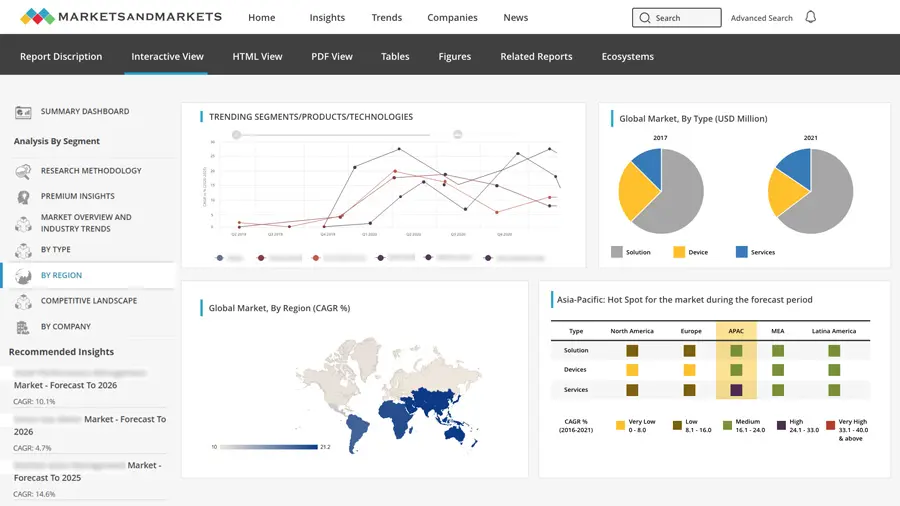
North America remains the leading market due to advanced maritime infrastructure and strong naval modernization investments.
Asia Pacific is projected to witness the fastest growth driven by expanding maritime trade and port digitalization initiatives.
Electronic navigational charts (ENCs) dominate the market due to international maritime safety regulations.
AI-powered route optimization and autonomous navigation systems are emerging as major industry trends.
Cloud-connected marine navigation platforms are improving fleet management and operational efficiency.
IoT-enabled marine monitoring technologies are enhancing real-time maritime situational awareness.
Market Size & Forecast
-
Base year market size (2025): US$ 3.20 Billion - US$ 3.80 Billion
-
Forecast value by 2035: US$ 7.10 Billion - US$ 8.40 Billion
-
CAGR (2025–2035): 7.6% - 8.5%
-
Market growth is driven by increasing digital marine navigation adoption, autonomous vessel development, maritime safety regulations, and AI-enabled maritime analytics
Electronic Cartographic (Marine) Market Top 10 Key Takeaway
-
Electronic navigational charts remain the largest product segment globally
-
Maritime digitalization is accelerating adoption of advanced cartographic systems
-
AI-powered navigation analytics are improving marine operational efficiency
-
North America dominates the market with advanced naval and shipping infrastructure
-
Asia Pacific is emerging as the fastest-growing marine navigation market
-
Autonomous shipping technologies are driving innovation in electronic cartography
-
Cloud-based marine data platforms are improving real-time fleet visibility
-
IoT-enabled maritime monitoring systems are enhancing navigation safety
-
Naval modernization programs are increasing demand for advanced cartographic solutions
-
Smart ports and digital shipping ecosystems are supporting long-term market growth
Product Insights
Electronic navigational charts (ENCs) account for the largest share of the electronic cartographic (marine) market due to growing international maritime safety standards and mandatory electronic chart display and information system (ECDIS) adoption across commercial shipping fleets. ENCs provide highly accurate digital charting data that enables safer navigation, route optimization, and real-time situational awareness. Increasing regulatory compliance requirements established by international maritime authorities continue to support strong ENC demand globally.
Electronic chart display and information systems (ECDIS) also represent a major market segment as shipping operators increasingly transition from traditional paper charts to fully digital navigation platforms. Modern ECDIS solutions integrate radar systems, GPS positioning, hydrographic data, weather monitoring, and collision avoidance capabilities into centralized navigation interfaces.
Emerging product categories include AI-powered marine analytics platforms, autonomous vessel navigation software, augmented reality marine navigation displays, and cloud-connected maritime route optimization systems. These technologies are transforming marine navigation by enabling intelligent decision-making, fuel optimization, and predictive voyage management.
Manufacturers are increasingly integrating machine learning algorithms and advanced geospatial analytics into marine cartographic systems to support autonomous shipping operations and improve maritime safety performance.
Technology / Component Insights
Artificial intelligence is becoming a transformative technology within the electronic cartographic (marine) market. AI-powered marine navigation systems can analyze oceanographic data, weather conditions, vessel traffic patterns, and fuel consumption metrics to optimize maritime routes and improve operational efficiency. AI algorithms also enhance collision avoidance capabilities and predictive voyage planning.
IoT-enabled marine monitoring systems are playing a crucial role in modern maritime navigation ecosystems. Connected sensors installed across vessels continuously collect operational data related to engine performance, sea conditions, cargo stability, vessel positioning, and environmental conditions. This real-time data supports enhanced maritime situational awareness and fleet management.
Cloud computing technologies are enabling centralized maritime data management and remote navigation support capabilities. Cloud-based marine navigation platforms allow fleet operators, port authorities, and shipping companies to access real-time vessel tracking information, hydrographic updates, and operational analytics from multiple global locations.
Automation technologies are accelerating the development of autonomous shipping systems and intelligent marine traffic management solutions. Automated navigation systems, AI-assisted vessel control platforms, and robotic hydrographic survey systems are expected to become increasingly important across commercial and naval maritime operations.
Future innovations are expected to include digital twin-based maritime analytics, quantum-enhanced marine navigation systems, satellite-integrated global ocean intelligence platforms, and fully autonomous marine fleet management ecosystems.
Application Insights
Commercial shipping remains the leading application segment in the electronic cartographic (marine) market due to increasing global maritime trade and expanding international logistics networks. Shipping companies are investing heavily in digital navigation systems to improve operational efficiency, fuel optimization, voyage planning, and maritime safety compliance.
Naval defense applications are also witnessing substantial growth as governments modernize naval fleets with advanced maritime surveillance, situational awareness, and electronic warfare capabilities. Military vessels increasingly rely on highly secure electronic cartographic systems integrated with radar, sonar, satellite communication, and tactical navigation platforms.
Offshore energy applications are expanding steadily with increasing offshore oil, gas, and renewable energy exploration activities. Marine navigation systems are becoming critical for offshore platform positioning, subsea operations, and environmental monitoring.
Recreational boating and luxury marine tourism are also supporting market expansion through rising adoption of advanced GPS-based navigation systems and smart marine electronics.
Future growth opportunities are expected in autonomous shipping corridors, smart port ecosystems, unmanned surface vessels, and AI-enabled maritime logistics networks.
Regional Insights
North America dominates the global electronic cartographic (marine) market due to advanced maritime infrastructure, strong naval modernization investments, and widespread adoption of digital marine technologies. The United States remains a major contributor with significant investments in autonomous naval systems, maritime cybersecurity, and advanced commercial shipping technologies.
Europe maintains a strong market position supported by stringent maritime safety regulations, advanced commercial shipping operations, and extensive investments in smart port infrastructure. Countries such as Germany, France, and Norway are leading maritime digitalization and autonomous vessel innovation initiatives.
Asia Pacific is projected to witness the fastest growth through 2035 due to rapid expansion of maritime trade routes, increasing shipbuilding activities, and major port modernization programs across China, Japan, South Korea, and Southeast Asia. Governments throughout the region are heavily investing in maritime digital transformation and intelligent port ecosystems.
The Middle East is also emerging as a growing market due to rising investments in shipping logistics infrastructure and offshore energy operations.
-
North America leads global maritime digital navigation innovation
-
Asia Pacific is projected to witness the highest market growth through 2035
-
Europe continues investing in autonomous shipping technologies
-
AI-enabled marine navigation systems are gaining rapid global adoption
-
Smart port modernization initiatives are accelerating maritime digitalization
Country Specific Market Trends
China is projected to register a CAGR of 8.3% - 9.2% from 2025 to 2035 due to aggressive port modernization initiatives, expanding maritime trade activity, and growing investments in smart shipping technologies. The country is rapidly strengthening domestic marine electronics and navigation system manufacturing capabilities.
Japan is focusing on autonomous shipping technologies, advanced marine robotics, and AI-powered navigation systems to support maritime efficiency and aging workforce challenges. Japanese shipping operators are actively investing in smart vessel management platforms.
The United States remains the largest market globally with a CAGR of 7.4% - 8.2% driven by advanced naval modernization programs, maritime cybersecurity investments, and widespread digital marine navigation adoption. Canada is expanding Arctic maritime monitoring capabilities, while Mexico is investing in port infrastructure modernization.
Germany and France are emphasizing sustainable maritime technologies, smart port development, and AI-enabled shipping logistics systems to improve operational efficiency and environmental compliance.
-
China is rapidly expanding intelligent maritime infrastructure capabilities
-
Japan is advancing autonomous vessel navigation technologies
-
The United States remains the leader in marine electronic navigation innovation
-
Germany and France are strengthening smart port modernization initiatives
-
AI-powered maritime analytics adoption is accelerating globally
Key Company Insights
Major companies operating in the electronic cartographic (marine) market include Garmin, Furuno Electric, Kongsberg Gruppen, Navico Group, Wärtsilä, Raymarine, Thales Group, and Tokyo Keiki.
These companies are focusing on AI-powered marine analytics, cloud-based fleet management platforms, autonomous vessel navigation technologies, and advanced ECDIS innovation. Strategic partnerships with shipping operators, naval agencies, and smart port authorities are helping companies strengthen their market positions.
Manufacturers are also investing heavily in cybersecurity-focused marine navigation platforms, satellite-integrated maritime intelligence systems, and real-time hydrographic data solutions.
-
AI-driven maritime navigation analytics remain a major innovation focus
-
Marine electronics companies are investing heavily in autonomous shipping technologies
-
Cloud-connected maritime management platforms are improving operational efficiency
-
Cybersecurity integration is becoming critical for modern marine navigation systems
-
Strategic partnerships are accelerating maritime digital transformation worldwide
Recent Developments
Several marine navigation technology companies recently launched AI-powered route optimization platforms capable of reducing fuel consumption and improving voyage efficiency for commercial shipping fleets.
Major maritime electronics providers announced partnerships with smart port authorities to integrate cloud-based vessel traffic management and autonomous navigation capabilities.
Marine cartographic software developers introduced next-generation ECDIS systems with real-time hydrographic updates, predictive collision avoidance analytics, and enhanced cybersecurity protection features.
Market Segmentation
The electronic cartographic (marine) market is segmented by product, technology/component, application, and region. By product, the market includes electronic navigational charts, electronic chart display and information systems, marine GIS software, autonomous navigation systems, and cloud-based maritime analytics platforms. Electronic navigational charts currently dominate the market due to mandatory regulatory adoption across global commercial shipping fleets.
By technology/component, the market includes AI-powered marine analytics, IoT-enabled vessel monitoring systems, cloud-based maritime platforms, GPS navigation technologies, satellite communication systems, and automated marine traffic management solutions. AI-enabled route optimization systems are expected to witness the fastest growth during the forecast period.
By application, the market covers commercial shipping, naval defense, offshore energy, recreational boating, and smart port infrastructure. Commercial shipping remains the leading application segment globally.
Regionally, the market is segmented into North America, Europe, Asia Pacific, and the rest of the world. North America currently dominates the market, while Asia Pacific is expected to witness the fastest expansion through 2035.
-
Electronic navigational charts remain the dominant product segment globally
-
AI-powered maritime analytics are transforming marine navigation systems
-
Commercial shipping accounts for the largest application segment
-
Smart ports and autonomous vessels are accelerating digital transformation
-
Asia Pacific is emerging as a major maritime technology growth region
Conclusion
The electronic cartographic (marine) market is entering a transformative growth phase driven by increasing maritime digitalization, autonomous shipping innovation, and rising global trade activities. AI-powered navigation analytics, IoT-enabled vessel monitoring, cloud-based maritime intelligence platforms, and automation-driven navigation systems are redefining maritime operational efficiency, safety, and situational awareness.
As commercial shipping operators, naval defense organizations, and smart port authorities continue investing in intelligent marine infrastructure, demand for advanced electronic cartographic technologies will accelerate significantly through 2035. Companies capable of delivering secure, AI-integrated, cloud-connected, and autonomous-ready navigation solutions will remain strategically positioned to capitalize on the future evolution of the global maritime industry.
FAQs
1. What is the market size of the electronic cartographic (marine) market?
The market is estimated to grow from US$ 3.20 Billion - US$ 3.80 Billion in 2025 to US$ 7.10 Billion - US$ 8.40 Billion by 2035.
2. What is the expected growth rate of the market?
The market is projected to grow at a CAGR of 7.6% - 8.5% from 2025 to 2035.
3. What are the key growth drivers for the market?
Major growth drivers include maritime digitalization, increasing autonomous shipping investments, AI-powered navigation technologies, and growing smart port infrastructure development.
4. Which region dominates the electronic cartographic (marine) market?
North America dominates the market due to advanced maritime infrastructure, strong naval modernization programs, and widespread adoption of digital marine navigation technologies.
5. Which companies are leading the electronic cartographic (marine) market?
Leading companies include Garmin, Furuno Electric, Kongsberg Gruppen, Wärtsilä, and Thales Group.
 Exclusive indicates content/data unique to MarketsandMarkets and not available with any competitors.
Table Of Contents
1 Introduction (Page No. - 18)
1.1 Objectives
1.2 Report Description
1.3 Markets Covered
1.4 Stakeholders
1.5 Research Methodology
1.5.1 Market Crackdown and Data Triangulation
1.5.2 Key Data Points Taken From Secondary Sources
1.5.3 Key Data Points Taken From Primary Resources
1.5.4 General Assumptions Made For the Report
1.5.5 Key Secondary Resources
2 Executive Summary (Page No. - 33)
3 Market Overview (Page No. - 35)
3.1 Market Definition
3.2 Market Overview
3.3 Market Segmentation
3.3.1.1 Electronic Cartography Marine Market Segmentation
3.3.1.2 Electronic Cartography Aviation Market Segmentation
3.4 Market Dynamics
3.4.1 Electronic Cartography Marine Market Dynamics
3.4.1.1 Drivers
3.4.1.1.1 Safety At Sea and Protection to the Environment
3.4.1.1.2 official Requirements Set By the IMO (International Maritime Organisation)
3.4.1.1.3 Need For Greater Accuracy and Constant Updating of Charts
3.4.1.1.4 Ability to Access the Enc Data
3.4.1.2 Impact Analysis For Drivers
3.4.1.3 Restraints
3.4.1.3.1 Lack of Expertise
3.4.1.3.2 Acceptance of the Electronic Navigation Systems and Charts
3.4.1.3.3 Requirement of Specialized Training
3.4.1.4 Impact Analysis For Restraints
3.4.1.5 Challenges
3.4.1.5.1 Positioning and Updating the Systems
3.4.1.5.2 Regulations and Policies
3.4.1.5.3 High Costs
3.4.1.5.4 Authenticity and Security of the Data
3.4.1.5.5 Mode of Communication When At Sea
3.4.1.6 Opportunities
3.4.1.6.1 Growth in the Maritime Industry of the Emerging Economies
3.4.1.6.2 Enc Data Globe Coverage Quality of the Enc Data
3.4.1.6.3 Specialized Training Programs
3.4.2 Electronic Cartography Marine Market Dynamics
3.4.2.1 Drivers
3.4.2.1.1 Increasing the Safety and Efficiency of Navigation
3.4.2.1.2 Need For Constant Updating of Charts and Access to the Navigation Database
3.4.2.1.3 Increase in Demand of Aircrafts
3.4.2.1.4 Need For Fuel Efficient Systems
3.4.2.2 Impact Analysis For Drivers
3.4.2.3 Restraints
3.4.2.3.1 Late Deliveries of Aircrafts
3.4.2.3.2 Slow Economic Growth of the Major Countries
3.4.2.4 Impact Analysis For Restraints
3.4.2.5 Challenges
3.4.2.5.1 the Multi Function Displays Used in the Flight Management Displays
3.4.2.5.2 Complexity of the Systems
3.4.2.6 Opportunities
3.4.2.6.1 Growth in the Aviation Industry of the Emerging Economies
3.4.2.6.2 Technological Developments to Improve the Functionality of the Systems
4 Trend Analysis (Page No. - 53)
4.1 Market Trends
4.1.1 Increase in Demand For Electronic Charts
4.1.2 Spending on Enc Data Production Is Set to Increase
4.1.3 Development of Retrofit Systems
4.2 Industry Trends
4.2.1 Need For A Common Electronic Charts Platform
4.2.2 Strategic Partnerships Between System and Charts Manufacturers
4.3 Technology Trends
4.3.1 Merging of Enc Data With Data From Other Navigation Systems
4.3.2 Development of Electronic Chart Display Systems With Reduced Complexity
4.3.3 Development of the Nextgen Systems
4.3.4 Development of Synthetic Vision Displays
5 Global Electronic Cartography Market Share Analysis (Page No. - 61)
5.1 Introduction
5.2 Electronic Cartography Revenue Analysis,
5.3 Application Analysis
5.3.1 EC Marine Market, By Application
5.3.2 EC Aviation Market, By Application
5.4 Component Analysis
5.4.1 Electronic Cartography Marine (Commercial) Market, By Components
5.4.1.1 EC Marine (Commercial) Components Market, By Systems
5.4.1.2 EC Marine (Commercial) Components Market, By Charts
5.4.2 EC Aviation Market, By Components
5.4.2.1 EC Aviation Components Market, By Systems
6 Electronic Cartography Market, Geographic Analysis (Page No. - 85)
6.1 North America
6.2 APAC
6.3 Middle East
6.4 Europe
6.5 Africa
6.6 Latin America
7 Market Analysis By Country (Page No. - 116)
7.1 U.S.
7.2 Russia
7.3 China
7.4 Japan
7.5 India
7.6 Australia
7.7 U.K.
7.8 Germany
7.9 France
7.10 Brazil
8 Competitive Landscape (Page No. - 141)
8.1 Overview
8.2 Geographical Analysis
8.3 Competitive Analysis
8.4 Recent Industry Developments, Competitive Situation and Trends
8.4.1 Recent Industry Developments, Competitive Situation and Trends
9 Company Profiles (Page No. - 146)
9.1 Honeywell
9.1.1 Overview
9.1.2 Products and Services
9.1.3 Strategies and Insights
9.1.4 Developments
9.1.5 MNM View
9.1.5.1 Company Review
9.1.5.2 SWOT Analysis
9.2 Thales
9.2.1 Overview
9.2.2 Products and Services
9.2.3 Strategies and Insights
9.2.4 Developments
9.2.5 MNM View
9.2.5.1 Company Review
9.2.5.2 SWOT Analysis
9.3 Jeppesen
9.3.1 Overview
9.3.2 Products and Services
9.3.3 Strategies and Insights
9.3.4 Developments
9.3.5 MNM View
9.3.5.1 Company Review
9.3.5.2 SWOT Analysis
9.4 Universal Avionics
9.4.1 Overview
9.4.2 Products and Services
9.4.3 Strategies and Insights
9.4.4 Developments
9.5 Rockwell Collins
9.5.1 Overview
9.5.2 Products and Services
9.5.3 Strategies and Insights
9.5.4 Developments
9.5.5 MNM View
9.5.5.1 Company Review
9.5.5.2 SWOT Analysis
9.6 Transas Marine
9.6.1 Overview
9.6.2 Products and Services
9.6.3 Strategies and Insights
9.6.4 Developments
9.7 Northrop Grumman
9.7.1 Overview
9.7.2 Products and Services
9.7.3 Strategies and Insights
9.7.4 Developments
9.7.5 MNM View
9.7.5.1 Company Review
9.7.5.2 SWOT Analysis
9.8 Navionics
9.8.1 Overview
9.8.2 Products and Services
9.8.3 Strategies and Insights
9.8.4 Developments
9.9 Garmin
9.9.1 Overview
9.9.2 Products and Services
9.9.3 Strategies and Insights
9.9.4 Developments
9.9.5 MNM View
9.9.5.1 Company Review
9.9.5.2 SWOT Analysis
9.10 IIC Technologies
9.10.1 Overview
9.10.2 Products and Services
9.10.3 Strategies and Insights
9.10.4 Developments
List of Tables (62 Tables)
Table 1 General Assumptions, Terminologies, and Application Keynotes
Table 2 Key Secondary Resources
Table 3 Electronic Cartography Market, By Size, 2013–2020 ($ Million)
Table 4 EC Market Size, 2013-2020 ($ Million)
Table 5 EC Market Size, By Application, 2013-2020 ($ Million)
Table 6 EC Marine Market Size, By Application, 2013-2020 ($ Million)
Table 7 EC Aviation Market Size, By Application, 2013-2020 ($ Million)
Table 8 EC Marine (Commercial) Market Size, By Components, 2013-2020 ($ Million)
Table 9 EC Marine (Commercial) Market Size, By Systems, 2013-2020 ($ Million)
Table 10 EC Marine (Commercial) Market Size, By Charts, 2013-2020 ($ Million)
Table 11 EC Aviation Market Size, By Components, 2013-2020 ($ Million)
Table 12 EC Aviation Market Size, By Charts, 2013-2020 ($ Million)
Table 13 EC Aviation Market Size, By Systems, 2013-2020 ($ Million)
Table 14 EC Market Size, By Geography, 2013-2020 ($ Million)
Table 15 North America: Electronic Cartography Market Size, 2013-2020 ($ Million)
Table 16 North America: Marine Market Size, By Application, 2013-2020 ($ Million)
Table 17 North America: Aviation Market Size, By Application, 2013-2020 ($ Million)
Table 18 APAC: Electronic Cartography Market Size, 2013-2020 ($ Million)
Table 19 APAC: Marine Market Size, By Application, 2013-2020 ($ Million)
Table 20 APAC: Aviation Market Size, By Application, 2013-2020 ($ Million)
Table 21 Middle East: Electronic Cartography Market Size, 2013-2020 ($ Million)
Table 22 Middle East: Marine Market Size, By Application, 2013-2020 ($ Million)
Table 23 Middle East: Aviation Market Size, By Application, 2013-2020 ($ Million)
Table 24 Europe: Electronic Cartography Market Size, 2013-2020 ($ Million)
Table 25 Europe: Marine Market Size, By Application, 2013-2020 ($ Million)
Table 26 Europe: Aviation Market Size, By Application, 2013-2020 ($ Million)
Table 27 Africa: Electronic Cartography Market Size, 2013-2020 ($ Million)
Table 28 Africa: Marine Market Size, By Application, 2013-2020 ($ Million)
Table 29 Africa: Aviation Market Size, By Application, 2013-2020 ($ Million)
Table 30 Latin America: Electronic Cartography Market Size, 2013-2020 ($ Million)
Table 31 Latin America: Marine Market Size, By Application, 2013-2020 ($ Million)
Table 32 Latin America: Aviation Market Size, By Application, 2013-2020 ($ Million)
Table 33 U.S.: Electronic Cartography Market Size, 2013-2020 ($ Million)
Table 34 U.S.: Marine Market Size, 2013-2020 ($ Million)
Table 35 U.S.: Aviation Market Size, 2013-2020 ($ Million)
Table 36 Russia: Electronic Cartography Market Size, 2013-2020 ($ Million)
Table 37 Russia: Marine Market Size, 2013-2020 ($ Million)
Table 38 Russia: Aviation Market Size, 2013-2020 ($ Million)
Table 39 China: Electronic Cartography Market Size, 2013-2020 ($ Million)
Table 40 China: Marine Market Size, 2013-2020 ($ Million)
Table 41 China: Aviation Market Size, 2013-2020 ($ Million)
Table 42 Japan: Electronic Cartography Market Size, 2013-2020 ($ Million)
Table 43 Japan: Marine Market Size, 2013-2020 ($ Million)
Table 44 Japan: Aviation Market Size, 2013-2020 ($ Million)
Table 45 India: Electronic Cartography Market Size, 2013-2020 ($ Million)
Table 46 India: Marine Market Size, 2013-2020 ($ Million)
Table 47 India: Aviation Market Size, 2013-2020 ($ Million)
Table 48 Australia: Electronic Cartography Market Size, 2013-2020 ($ Million)
Table 49 Australia: Marine Market Size, 2013-2020 ($ Million)
Table 50 Australia: Aviation Market Size, 2013-2020 ($ Million)
Table 51 U.K.: Electronic Cartography Market Size, 2013-2020 ($ Million)
Table 52 U.K.: Marine Market Size, 2013-2020 ($ Million)
Table 53 U.K.: Aviation Market Size, 2013-2020 ($ Million)
Table 54 Germany: Electronic Cartography Market Size, 2013-2020 ($ Million)
Table 55 Germany: Marine Market Size, 2013-2020 ($ Million)
Table 56 Germany: Aviation Market Size, 2013-2020 ($ Million)
Table 57 France: Electronic Cartography Market Size, 2013-2020 ($ Million)
Table 58 France: Marine Market Size, 2013-2020 ($ Million)
Table 59 France: Aviation Market Size, 2013-2020 ($ Million)
Table 60 Brazil: Electronic Cartography Market Size, 2013-2020 ($ Million)
Table 61 Brazil: Marine Market Size, 2013-2020 ($ Million)
Table 62 Brazil: Aviation Market Size, 2013-2020 ($ Million)
List of Figures (53 Figures)
Figure 1 Electronic Cartography Marine Market
Figure 2 EC Aviation Market
Figure 3 EC Marine Market Stakeholders
Figure 4 EC Aviation Market
Figure 5 Market Research Methodology
Figure 6 Electronic Cartography Market: Market Size Estimation
Figure 7 EC Market: Data Triangulation
Figure 8 Drivers and Restraints of EC Marine Market
Figure 9 Impact Analysis For Drivers
Figure 10 Impact Analysis For Restraints
Figure 11 Drivers and Restraints of EC Aviation Market
Figure 12 Impact Analysis For Drivers
Figure 13 Impact Analysis For Restraints
Figure 14 Electronic Cartography Market: Technology Roadmap
Figure 15 Segmentation of EC Market, By Application
Figure 16 EC Market Size, By Application, 2013-2020
Figure 17 EC Marine Market, By Application, 2013-2020
Figure 18 EC Aviation Market, By Application, 2013-2020
Figure 19 Segmentation of Electronic Cartography Market, By Components
Figure 20 EC Marine (Commercial) Market, By Components, 2013-2020
Figure 21 EC Marine (Commercial) Market, By Ecdis Systems, 2013-2020
Figure 22 EC Marine (Commercial) Market, By Rcds Systems, 2013-2020
Figure 23 EC Marine (Commercial) Market, By Pays Licensing Mode For Charts, 2013-2020
Figure 24 EC Marine (Commercial) Market, By Direct Licensing Mode For Charts, 2013-2020
Figure 25 Electronic Cartography Aviation Market, By Systems, 2013-2020
Figure 26 EC Market, By Geography, 2013-2020
Figure 27 North America: Electronic Cartography Marine Market, By Application, 2013-2020
Figure 28 North America: EC Aviation Market, By Application, 2013-2020
Figure 29 APAC: Electronic Cartography Marine Market, By Application, 2013-2020
Figure 30 APAC: EC Aviation Market, By Application, 2013-2020
Figure 31 Middle East: Electronic Cartography Marine Market, By Application, 2013-2020
Figure 32 Middle East: EC Aviation Market, By Application, 2013-2020
Figure 33 Europe: Electronic Cartography Marine Market, By Application, 2013-2020
Figure 34 Europe: EC Aviation Market, By Application, 2013-2020
Figure 35 Africa: Electronic Cartography Marine Market, By Application, 2013-2020
Figure 36 Africa: EC Aviation Market, By Application, 2013-2020
Figure 37 Latin America: Electronic Cartography Marine Market, By Application, 2013-2020
Figure 38 Latin America: EC Aviation Market, By Application, 2013-2020
Figure 39 Regional Percentage Split of Electronic Cartography Market, 2014
Figure 40 Country Wise Percentage Split of EC Market, 2014
Figure 41 Electronic Cartography Market: Market Share Analysis, By Company
Figure 42 Honeywell Inc.: Company Snapshot
Figure 43 Honeywell Inc.: SWOT Analysis
Figure 44 Thales: Company Snapshot
Figure 45 Thales: SWOT Analysis
Figure 46 Jeppesen: Company Snapshot
Figure 47 Jeppesen: SWOT Analysis
Figure 48 Rockwell Collins: Company Snapshot
Figure 49 Rockwell Collins: SWOT Analysis
Figure 50 Northrop Grumman: Company Snapshot
Figure 51 Northrop Grumman: SWOT Analysis
Figure 52 Garmin: Company Snapshot
Figure 53 Garmin: SWOT Analysis


Growth opportunities and latent adjacency in Electronic Cartographic (Marine) Market
We design, develop, produce, and commercialize maps and charts for the outdoors. We need to know more about the market dynamics, growth potential, as well as the competitive landscape. Thank you.