

AI in Drone Sensors: North America Innovations & Trends
AI in Drone Sensors: Innovations in North America
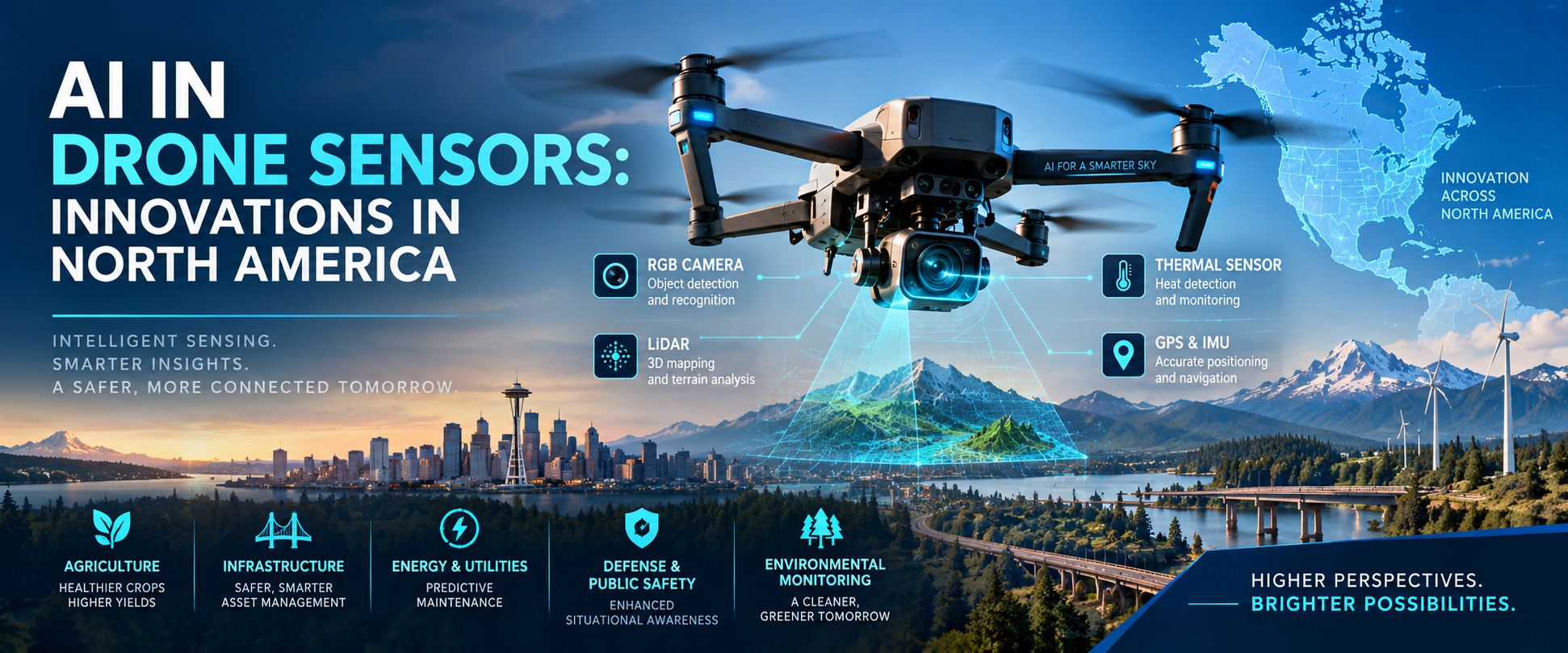
Artificial intelligence (AI) is transforming the capabilities of modern drones, turning them from remotely controlled flying machines into intelligent platforms capable of sensing, analyzing, and responding to their surroundings. At the center of this transformation are advanced drone sensors. By combining cameras, LiDAR, radar, thermal imaging, GPS, inertial measurement units (IMUs), and AI-powered analytics, drones can increasingly perform complex tasks with limited human intervention.
North America has emerged as an important center for innovation in AI-enabled drone sensors. Strong investments in autonomous systems, defense technologies, commercial drones, robotics, infrastructure inspection, agriculture, and artificial intelligence are accelerating the development and adoption of intelligent sensing technologies across the United States and Canada.
Get Details Download PDF Brochure:
https://www.marketsandmarkets.com/pdfdownloadNew.asp?id=241127051
The Evolution of Drone Sensors
Traditional drones primarily relied on basic cameras, GPS, and flight-control sensors to support navigation and remote operation. Modern drones, however, can integrate multiple sensors that continuously collect information about their environment.
AI adds another layer of intelligence to this sensor ecosystem. Instead of simply collecting images or measurements, AI algorithms can interpret the information in real time. Computer vision can identify objects, deep-learning models can classify images, and sensor-fusion technologies can combine data from multiple sources to create a more accurate understanding of the environment.
This evolution is helping drones operate in complex environments where manual control may be difficult, dangerous, or inefficient.
AI-Powered Computer Vision
Computer vision is one of the most important AI technologies being integrated into drone sensors. High-resolution RGB cameras can capture detailed images and video, while AI models analyze this visual information to identify objects, structures, people, vehicles, vegetation, and potential hazards.
For example, an inspection drone can fly around a bridge and automatically identify cracks, corrosion, damaged components, or structural abnormalities. In agriculture, AI-enabled cameras can analyze crops and identify signs of disease, water stress, or nutrient deficiencies.
AI-based computer vision can also support autonomous navigation by recognizing obstacles and determining safe flight paths. This capability is particularly important as drone operations move beyond simple line-of-sight applications.
LiDAR and AI Sensor Fusion
LiDAR is another important sensing technology for advanced drones. It uses laser pulses to measure distances and generate highly detailed three-dimensional representations of the environment.
When combined with AI, LiDAR data can support applications such as terrain mapping, forestry management, construction monitoring, mining, and infrastructure inspection.
Sensor fusion further enhances performance. Instead of relying on a single sensor, AI can combine LiDAR, cameras, radar, GPS, IMUs, and other data sources. If one sensor produces incomplete or noisy information, algorithms can use information from other sensors to improve the overall result.
This approach is especially valuable in challenging conditions such as darkness, fog, dust, rain, or environments with limited visibility.
Thermal Sensors and AI
Thermal imaging is expanding the role of drones in public safety, energy, industrial inspection, and environmental monitoring. Thermal sensors detect heat signatures rather than relying only on visible light.
AI can analyze thermal images to identify unusual temperature patterns. For example, drones equipped with thermal cameras can potentially detect overheating electrical equipment, heat loss in buildings, machinery abnormalities, or areas affected by wildfires.
In emergency response, thermal drones can help locate people in difficult terrain or low-visibility conditions. Combining thermal imaging with AI-based object detection can make these operations faster and more efficient.
Autonomous Navigation
One of the most significant developments in AI-enabled drone sensing is autonomous navigation. Advanced drones can process sensor information continuously to understand their position, detect obstacles, and determine appropriate flight paths.
AI algorithms can support technologies such as simultaneous localization and mapping (SLAM), enabling drones to create maps while navigating unfamiliar environments. This is particularly useful for indoor inspections, warehouses, tunnels, mines, and other areas where GPS signals may be weak or unavailable.
Autonomous navigation can reduce the workload on operators and potentially allow one operator to supervise multiple drones in certain applications.
Applications Across North America
The growing adoption of AI drone sensors is creating opportunities across numerous industries in North America.
Agriculture
Farmers and agricultural companies are using drones to collect detailed information about crops and fields. Multispectral and hyperspectral sensors can capture information that is difficult to see with the human eye. AI can then analyze this data to identify crop stress, disease, irrigation problems, and variations in plant health.
This can support precision agriculture by helping farmers make more targeted decisions about irrigation, fertilizers, pesticides, and harvesting.
Infrastructure Inspection
North America's extensive transportation and energy infrastructure creates significant demand for automated inspection technologies. Drones equipped with AI-enabled cameras, LiDAR, and thermal sensors can inspect bridges, roads, railways, pipelines, power lines, wind turbines, and other infrastructure.
Automated analysis can help organizations identify potential problems more quickly while reducing the need to expose workers to dangerous environments.
Energy and Utilities
Energy companies are increasingly interested in drones for inspecting power transmission systems, solar installations, wind turbines, oil and gas infrastructure, and other assets.
AI can process large volumes of sensor data and highlight anomalies that require further investigation. This can support predictive maintenance and reduce inspection time.
Defense and Public Safety
Defense and public safety are major areas of innovation in autonomous drone technology. AI-enabled sensors can provide situational awareness, object detection, mapping, surveillance, and navigation capabilities.
Emergency responders can also use intelligent drones for search and rescue, disaster assessment, wildfire monitoring, and hazardous-environment operations.
Edge AI and Real-Time Processing
A major trend in drone sensor technology is the movement of AI processing from remote cloud platforms toward the drone itself.
Edge AI allows drones to process sensor information locally. Instead of sending every image or video frame to a remote server, onboard processors can analyze data in real time.
This can reduce latency, lower bandwidth requirements, and improve performance in areas with limited connectivity. For autonomous drones, fast decision-making is particularly important because the aircraft may need to respond to an obstacle within seconds.
Advances in AI chips, embedded processors, and energy-efficient computing are therefore expected to play an important role in future drone sensor development.
Challenges Facing AI Drone Sensors
Despite rapid innovation, several challenges remain. Sensor accuracy can be affected by weather, lighting, vibration, interference, and environmental conditions. AI models also require high-quality training data to perform reliably across different environments.
Battery life is another important limitation. Advanced sensors and onboard AI processors consume energy, potentially reducing flight time.
Privacy, cybersecurity, airspace regulations, and data governance are also becoming increasingly important as drones collect more detailed information about people, businesses, and infrastructure.
Developers must therefore balance intelligence and autonomy with safety, security, privacy, and regulatory compliance.
Future Outlook
The future of AI in drone sensors is likely to be shaped by greater autonomy, improved sensor fusion, edge computing, and increasingly sophisticated AI models. Future drones may be capable of understanding complex environments, identifying objects, predicting potential hazards, and adapting their missions with minimal human intervention.
North America is well positioned to remain a major innovation hub because of its strong technology ecosystem, investment in AI and robotics, advanced aerospace capabilities, and broad commercial demand for autonomous systems.
As AI continues to advance, drone sensors will evolve from passive data-collection devices into intelligent systems capable of interpreting their surroundings and supporting real-time decisions. This transformation could make drones increasingly valuable across agriculture, infrastructure, energy, public safety, logistics, defense, environmental monitoring, and many other industries.
Ultimately, the convergence of AI and advanced sensing technologies is redefining what drones can accomplish. North American innovation in this field is likely to play a significant role in shaping the next generation of autonomous aerial systems.
| Question | Answer |
|---|---|
| What is AI in drone sensors? | AI in drone sensors refers to the use of artificial intelligence, machine learning, and computer vision to analyze data collected by cameras, LiDAR, radar, thermal sensors, GPS, and other sensing technologies. |
| How does AI improve drone sensors? | AI enables drones to interpret sensor data in real time, recognize objects, detect anomalies, avoid obstacles, map environments, and support autonomous navigation. |
| What are the major types of AI-enabled drone sensors? | Key technologies include RGB cameras, LiDAR, thermal imaging, radar, multispectral and hyperspectral sensors, GPS, and inertial measurement units (IMUs). |
| What is the role of computer vision in drone technology? | Computer vision allows drones to analyze images and video to identify objects, structures, people, vegetation, and potential hazards. It is widely used for inspection, surveillance, agriculture, and navigation. |
| How is LiDAR used with AI-powered drones? | AI can process LiDAR data to create detailed 3D maps, analyze terrain, identify structures, and support applications such as construction, forestry, mining, and infrastructure inspection. |
| Which industries use AI-powered drone sensors in North America? | Major applications include agriculture, infrastructure inspection, energy and utilities, defense, public safety, logistics, construction, environmental monitoring, and emergency response. |
| How are AI drone sensors used in agriculture? | Drones can capture multispectral, thermal, and visual data, while AI analyzes crops for disease, water stress, nutrient deficiencies, and other conditions to support precision agriculture. |
| What is edge AI in drone sensors? | Edge AI enables drones to process sensor data directly onboard the aircraft instead of sending all information to a remote cloud server. This supports faster decisions and reduces communication requirements. |
| Can AI-powered drones navigate autonomously? | Yes. Advanced AI systems can combine cameras, LiDAR, radar, GPS, and IMU data to detect obstacles, understand surroundings, map environments, and support autonomous flight. |
| What are the key challenges for AI-enabled drone sensors? | Major challenges include limited battery life, sensor accuracy, adverse weather, data quality, computing requirements, cybersecurity, privacy, and regulatory compliance. |
| What is the future of AI in drone sensors? | Future developments are expected to focus on greater autonomy, advanced sensor fusion, edge computing, improved computer vision, generative AI, real-time analytics, and more intelligent decision-making. |
| Why is North America important for AI drone sensor innovation? | North America has a strong ecosystem spanning AI, aerospace, robotics, defense, semiconductor technology, and commercial drone applications, supporting continued innovation in intelligent aerial sensing. |
80% of the Forbes Global 2000 B2B companies rely on MarketsandMarkets to identify growth opportunities in emerging technologies and use cases that will have a positive revenue impact.
- Food Packaging Market Size Set for Strong Growth Through 2030 Amid Rising Demand for Convenience Foods
- Crop Protection Chemical Market Size, Share & Growth Forecast (2025–2030)
- Mulch Films Market: Driving Sustainable Agriculture Through Innovation
- Agricultural Adjuvants Market Analysis, Trends, and Growth Outlook (2026–2031)
- Japan Enterprise Asset Management Market Growth: AI and Smart Infrastructure Drive Demand