
Europe LEO Satellite Market (2025-2030)

The Europe LEO Satellite Market was valued at $3348.2 Million in 2025 and projected to reach to $5702.3 Million by 2030, representing a compound annual growth rate of 11.2%. Europe's LEO satellite market is positioned for sustained growth through 2030, driven by EU regulatory support, increasing demand for broadband connectivity, and strategic investments in satellite communications infrastructure.


| Market Size in | USD 26.32 MN |
| Market Forecast in | |
| CAGR | |
| Forecast Period | |
| Units Considered | Value (USD MN) |
Europe LEO Satellite Market Trends and Insights
- Europe is capitalizing on strategic investments in satellite communications infrastructure, driven by regulatory support from the European Union and increasing demand for broadband connectivity across underserved regions.
- The continent's emphasis on technological sovereignty and space autonomy is accelerating LEO constellation deployments, positioning Europe as a critical player in global satellite markets. During the 2025–2030 forecast period, Europe's LEO satellite sector will benefit from growing applications in IoT, maritime communications, and emergency response systems.
- Europe's established aerospace supply chains and partnerships with leading satellite operators are strengthening market competitiveness.
- Government initiatives and public-private collaborations are expected to sustain the 11.2% compound annual growth rate, enabling Europe to capture an increasing share of the expanding global LEO satellite opportunity..
Key Market Statistics
- CAGR (2025-2030) 11.2% CAGR
- Market Size, 2025 ~USD 3348.2 Million
- Forecast, 2030 ~USD 5702.3 Million
- Geography Europe
Europe LEO Satellite Market Overview
EU Regulatory Support Driving Growth :
The European Union's strategic initiatives and regulatory frameworks are accelerating LEO satellite deployment across member states, creating favorable conditions for market expansion and infrastructure development.
Broadband Connectivity Expansion :
Europe is leveraging LEO satellite technology to bridge the digital divide in underserved rural and remote regions, addressing critical connectivity gaps and supporting the EU's digital agenda.
Strong Market Valuation :
Europe's LEO satellite market is valued at $3,348.2 million in 2025, with a robust 11.2% CAGR projected through 2030, reaching $5,702.3 million and demonstrating sustained investment momentum.
Strategic Infrastructure Investments :
European nations are prioritizing satellite communications infrastructure development, supported by government funding and private sector partnerships to enhance continental connectivity and technological sovereignty.
Europe LEO Satellite Market Dynamics
- The continent's emphasis on technological sovereignty and digital inclusion is accelerating LEO constellation deployments across member states.
- Key growth drivers include government funding initiatives, private sector partnerships, and the need to connect underserved regions.
- Europe's market is expected to benefit from expanding applications in telecommunications, IoT, and emergency services, supported by a mature aerospace and defense ecosystem.
- The region's commitment to digital transformation and space autonomy will continue to fuel market expansion and innovation in LEO satellite technologies..
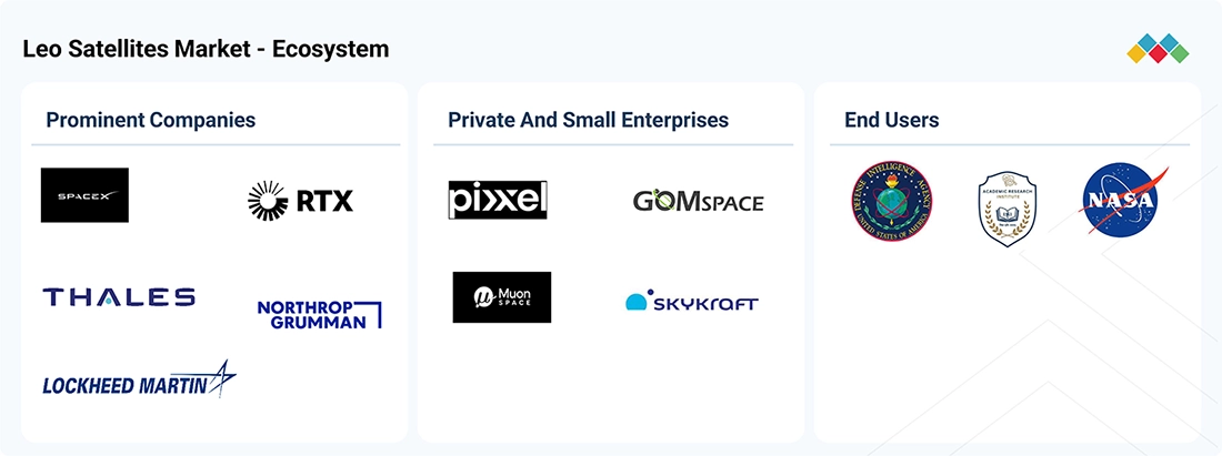
Market Ecosystem
LEO SATELLITE MARKET SIZE, SHARE & TRENDS: COMMERCIAL USE CASES ACROSS INDUSTRIES
| COMPANY | USE CASE DESCRIPTION | BENEFITS |
|---|---|---|
 |
LEO Satellite Broadband Connectivity – Starlink uses a large constellation of LEO satellites to provide broadband connectivity to residential, enterprise, government, aviation, maritime, and remote users. The satellites operate closer to Earth than traditional geostationary satellites, supporting lower-latency communication and wider coverage across areas with limited terrestrial infrastructure. | High-Speed, Low-Latency Connectivity – Provides broadband access in remote and underserved locations where terrestrial networks are limited. The LEO architecture supports lower communication latency and enables connectivity for fixed users, mobile platforms, emergency response, and government operations. |
 |
LEO Earth Observation & Monitoring – Planet operates LEO Earth observation satellites that collect frequent imagery of the Earth's surface for applications including mapping, agriculture, environmental monitoring, infrastructure assessment, and government intelligence. Its satellite fleet supports repeated observation of geographic areas to identify and monitor changes over time. | Frequent Earth Observation & Change Detection – Enables organizations to monitor large areas regularly and compare imagery across different time periods. This supports faster identification of changes in infrastructure, agriculture, environmental conditions, and areas of government or defense interest. |
 |
LEO Weather, Maritime & Aviation Data Collection – Spire operates LEO satellites carrying radio-frequency sensing payloads that collect weather, maritime AIS, and aviation ADS-B data. The satellites support global monitoring of atmospheric conditions, ship movements, and aircraft activity, including regions where terrestrial monitoring infrastructure is limited. | Global Monitoring & Data Coverage – Extends weather, maritime, and aviation data collection across oceans and remote regions. Frequent LEO satellite passes support updated information for weather forecasting, vessel tracking, aircraft monitoring, logistics, and government operations. |
Logos and trademarks shown above are the property of their respective owners. Their use here is for informational and illustrative purposes only.
Related Ecosystem
Space
- C-Band
- Small Satellite
- Antennas
- Ka-Band
- Microsatellite
- AIRBUS
- L3Harris Technologies, Inc.
- Thales group
- Northrop Grumman Corporation
- LOCKHEED MARTIN CORPORATION
Key Takeaways
- Europe's LEO satellite market will grow from $3,348.2M (2025) to $5,702.3M (2030) at an 11.2% CAGR.
- Europe is prioritizing space autonomy and technological sovereignty through government-backed LEO constellation initiatives.
- Growing demand for broadband connectivity and IoT applications across Europe is driving LEO satellite adoption.
- Europe's aerospace ecosystem and public-private partnerships are accelerating competitive positioning in the global LEO market.
LEO Satellite Market Report Scope
| Report Metric | Details |
|---|---|
| Base Year | 2025 |
| Fastest Growing Segment | LASER/OPTICAL (Frequency) |
| Forecast Period | 2025–2030 |
| Growth Rate | CAGR of 11.9% from 2025 to 2030 |
| Largest Segment | COMMERCIAL (End Use) |
| Market Size Base Year (Billions) | ~USD 11.79 (2025) |
| Revenue Forecast (Billions) | ~USD 20.69 (2030) |
| Segments Covered | Satellite Mass, Type, Subsystem, Propulsion, Payload, Application, End Use, Frequency |
Europe LEO Satellite Market Report Segmentation
8 segment dimensions are covered across the global market.
By Satellite Mass
- Cubesats
- Large Satellites
- Medium Satellites
- Small Satellites
By Type
- Academic & Research Institutions
- Attitude & Orbital Control Systems
- Command & Data Handling Systems
- Communication Payloads/Transponders
- Departments Of Defense & Intelligence Agencies
- Electrical Power Systems
- Energy Industry
- Hyperspectral And Multispectral Imagers
- Media & Entertainment
- Micro Satellites (11–100 Kg)
- Mini Satellites (101–500 Kg)
- Nano Satellites (1–10 Kg)
- National Mapping & Topographic Agencies
- National Space Agencies
- Optical And Infrared
- Others (Ais)
- Propulsion
- Radar Payloads
- Satellite Operators/Owners
- Scientific Research & Development
- Search & Rescue Entities
- Smallsats (501–1,000 Kg)
- Structures
- Telemetry, Tracking, & Command (Tt&C)
- Thermal Systems
By Subsystem
- Payloads
- Satellite Antennas
- Satellite Buses
- Solar Panels
By Propulsion
- Chemical Propulsion
- Electric Propulsion
- Hybrid Propulsion
By Payload
- Software-Defined Payloads
- Traditional Payloads
By Application
- Communication
- Earth Observation & Remote Sensing
- Scientific Research
- Technology
By End Use
- Commercial
- Dual Use
- Government & Military
By Frequency
- C-Band
- Hf/Vhf/Uhf-Band
- Ka-Band
- Ku-Band
- L-Band
- Laser/Optical
- Q/V-Band
- S-Band
- X-Band
Target Audience
- Satellite Operators & Constellation Developers : European and international LEO satellite operators need market intelligence to identify expansion opportunities, regulatory requirements, and competitive positioning within Europe's growing market.
- Government & Space Agencies : EU institutions, national space agencies, and government bodies require data-driven insights to inform policy decisions, funding allocations, and strategic space initiatives across Europe.
- Telecommunications & Broadband Providers : Telecom companies and broadband service providers need market analysis to evaluate LEO satellite partnerships, service offerings, and connectivity solutions for European customers.
- Aerospace & Defense Contractors : European defense and aerospace firms require market forecasts and opportunity assessments to develop LEO satellite technologies, ground infrastructure, and integrated solutions for regional demand.
- Investment & Venture Capital Firms : Investors and venture capital funds need comprehensive market data to identify promising European LEO satellite startups, growth companies, and investment opportunities in the expanding sector.
Key Companies in the Europe LEO Satellite Market
| Company | HQ | Ownership | Strongest segments |
|---|---|---|---|
| EUTELSAT COMMUNICATIONS S.A. | France | ||
| SATELLOGIC | United States | Public Company | Optical payload data & analytics,Satellite bus & space systems (sales and support),Constellation-as-a-service & sovereign constellations, |
| TERRAN ORBITAL CORPORATION | United States | Private Company | Satellite Bus – Command & Data Handling,Satellite Bus – Electric Power System,Payload – Optical / Infrared / Radar, |
| SPIRE GLOBAL INC. | United States | Public Company | Space Reconnaissance (defense, intelligence, national security),Aviation (satellite-based aircraft tracking),Weather and Climate (data and predictive analytics), |
| RAYTHEON TECHNOLOGIES CORPORATION | United States | Public Company | Payload – Radar,Payload – Infrared,Payload – Optical, |
| PLANET LABS, INC | United States | Public Company | Optical payload data (SuperDove, SkySat, Pelican),Hyperspectral payload data (Tanager),Earth Observation platform and analytics (APIs, browser apps), |
| SPACE EXPLORATION TECHNOLOGIES CORP. | United States | Public Company | Satellite Bus (Command & Data Handling, Electric Power System),Payload (Optical, Infrared, Radar),Solar Panel, |
| SPACEX | United States | Public Company | Satellite Bus (Command & Data Handling, Electric Power System),Payload (Broadband-focused RF payloads, including phased arrays),Solar Panels, |
| LOCKHEED MARTIN CORPORATION | United States | Public Company | Satellite Bus – Command & Data Handling,Satellite Bus – Electric Power System,Payload – Optical / Infrared / Radar, |
| NORTHROP GRUMMAN | United States | Public Company | Satellite Bus (Command & Data Handling, Electric Power System),Payload (Optical, Infrared, Radar),Solar Panel, |
| L3HARRIS TECHNOLOGIES, INC. | United States | Public Company | Satellite Bus – Command & Data Handling,Satellite Bus – Electric Power System,Payload – Optical, |
| PLANET LABS PBC | United States | Public Company | Optical payload data subscriptions (Dove/SuperDove),High-resolution tasked imagery (SkySat),Value-added analytics and monitoring services, |
| MAXAR TECHNOLOGIES | United States | Private Company | Payload-derived data (optical, radar) and analytics platforms,Mission software, C2, and digital twin solutions,Satellite bus, solar panel, and antenna-related activities, |
| GOMSPACE | Denmark | Public Company | Satellite Bus (Command & Data Handling, Electric Power System, AOCS, structures),Payloads (mission payloads across optical, RF, and specialized sensors),Power, Communication Systems, Solar Panels, and Antennas, |
| MITSUBISHI ELECTRIC CORPORATION | Japan | Public Company | Satellite Bus – Command & Data Handling,Satellite Bus – Electric Power System,Payload – Optical, |
| CHINA AEROSPACE SCIENCE AND TECHNOLOGY CORPORATION | China | Private Company | Satellite Bus – Command & Data Handling,Satellite Bus – Electric Power System,Payload – Optical, |
EUTELSAT COMMUNICATIONS S.A.
Eutelsat Communications S.A. is a French satellite operator providing telecommunications and broadcasting services through a fleet of geostationary satellites.
SATELLOGIC
Satellogic is a United States-based public company founded in 2010 with 154 employees that operates in the satellite imagery and Earth observation sector.
TERRAN ORBITAL CORPORATION
Terran Orbital Corporation is a United States-based private company founded in 2013 with 660 employees specializing in satellite manufacturing and space systems.
SPIRE GLOBAL INC.
Spire Global Inc. is a United States-based public company founded in 2012 with 375 employees providing satellite-based data and analytics for maritime, aviation, and weather applications.
RAYTHEON TECHNOLOGIES CORPORATION
Raytheon Technologies Corporation is a United States-based public company founded in 1934 with 180,000 employees providing aerospace and defense technologies and services.
PLANET LABS, INC
Planet Labs, Inc. is a United States-based public company founded in 2010 with 973 employees operating a constellation of Earth imaging satellites for global monitoring and analysis.
SPACE EXPLORATION TECHNOLOGIES CORP.
Space Exploration Technologies Corp. is a United States-based public company founded in 2002 with 21,000 employees developing rockets and spacecraft for commercial and government missions.
SPACEX
SpaceX is a United States-based public company founded in 2002 with 22,000 employees designing and manufacturing rockets and spacecraft for commercial and government space missions.
LOCKHEED MARTIN CORPORATION
Lockheed Martin Corporation is a United States-based public company founded in 1912 with 123,000 employees providing aerospace, defense, and security solutions.
NORTHROP GRUMMAN
Northrop Grumman is a United States-based public company founded in 1939 with 95,000 employees providing aerospace, defense, and security technologies and services.
L3HARRIS TECHNOLOGIES, INC.
L3Harris Technologies, Inc. is a United States-based public company founded in 1895 with 45,000 employees specializing in aerospace, defense, and security solutions.
PLANET LABS PBC
Planet Labs PBC is a United States-based public company founded in 2010 operating Earth imaging satellites for global monitoring and geospatial intelligence.
MAXAR TECHNOLOGIES
Maxar Technologies is a United States-based private company founded in 1957 with 4,600 employees specializing in satellite imagery, geospatial intelligence, and space infrastructure.
GOMSPACE
GOMSPACE is a Denmark-based public company founded in 2007 with 208 employees manufacturing small satellites and spacecraft subsystems.
MITSUBISHI ELECTRIC CORPORATION
Mitsubishi Electric Corporation is a Japan-based public company founded in 1921 with 150,386 employees providing electrical equipment, electronics, and space systems.
CHINA AEROSPACE SCIENCE AND TECHNOLOGY CORPORATION
China Aerospace Science and Technology Corporation is a China-based private company founded in 1956 engaged in aerospace and space technology development and manufacturing.
Countries within Europe - compare and drill down
| Country | 2025 size (native) |
|---|---|
| UK | USD 835.2 Million |
| Germany | USD 133.1 Million |
| France | USD 2449.7 Million |
| Italy | USD 285.3 Million |
| Russia | USD 1475.4 Million |
| Rest Of Europe | USD 523.6 Million |
Country market size visualization
Reasons to Buy this Report
- Country-Level Market Breakdown : Access detailed market sizing for UK, Germany, France, Italy, and Rest of Europe segments, enabling precise regional investment and expansion strategies tailored to specific European markets.
- EU Regulatory Landscape Analysis : Understand how European Union policies, directives, and regulatory frameworks are shaping LEO satellite deployment, licensing, and market opportunities across member states.
- Competitive Intelligence for Europe : Identify leading European and international players operating in the LEO satellite space, their market positioning, partnerships, and strategic initiatives specific to the European region.
- Growth Opportunity Identification : Discover high-potential segments within Europe including rural broadband, IoT connectivity, emergency services, and government applications driving market expansion through 2030.
- Investment & Partnership Insights : Gain actionable intelligence on funding trends, government initiatives, public-private partnerships, and M&A activities shaping Europe's LEO satellite market landscape.
Frequently asked questions
What is the current size of Europe's LEO satellite market?
Europe's LEO satellite market is valued at $3,348.2 million in 2025 and is projected to reach $5,702.3 million by 2030.
What is the growth rate for Europe's LEO satellite market?
Europe's LEO satellite market is expected to grow at a compound annual growth rate (CAGR) of 11.2% from 2025 to 2030.
What are the primary drivers of growth in Europe's LEO satellite market?
Key drivers include EU regulatory support, demand for broadband connectivity, IoT applications, maritime communications, emergency response systems, and Europe's focus on technological sovereignty.
How does Europe's LEO satellite market compare to the global market?
Europe's 11.2% CAGR is slightly below the global 11.9% CAGR, reflecting Europe's mature market position and strategic focus on specific high-value applications.
What role do government initiatives play in Europe's LEO satellite market?
Government initiatives and public-private partnerships are critical enablers, supporting space autonomy objectives, infrastructure investment, and competitive positioning in the global LEO satellite sector.
RESEARCH METHODOLOGY
The LEO satellites market is estimated at USD 12.82 billion in 2026 and is projected to reach USD 43.37 billion by 2031 at a CAGR of 27.6%. This research study involves the use of secondary sources, company publications, government databases, procurement records, technical papers, and industry associations to collect information related to the LEO satellites market. Primary research includes discussions with satellite manufacturers, satellite operators, launch service providers, payload and subsystem manufacturers, communication service providers, system integrators, and end users. Interviews with industry experts, company executives, and other market participants are used to validate information on market size, segment trends, technology adoption, competitive developments, and future market developments. Both qualitative and quantitative inputs are considered to assess the market and its segments.
Secondary Research
In the secondary research process, various sources are referred to for identifying and collecting information related to the LEO satellites market. These sources include company annual reports, press releases, investor presentations, product documents, government and space agency publications, procurement databases, technical papers, patents, industry associations, and recognized news sources. Secondary research is used to gather information on the market supply chain, competitive landscape, market segmentation, regional presence, satellite technologies, contracts, partnerships, product developments, constellation deployments, and launch activities. Information on satellite platforms, payloads, subsystems, communication technologies, Earth observation, navigation, and related technologies is also reviewed to understand changes in the market. The collected information is analyzed to estimate the overall market and individual segments using bottom-up and top-down approaches. The findings from secondary research are further checked and validated through primary research with relevant industry participants along with subject matter experts.
Primary Research
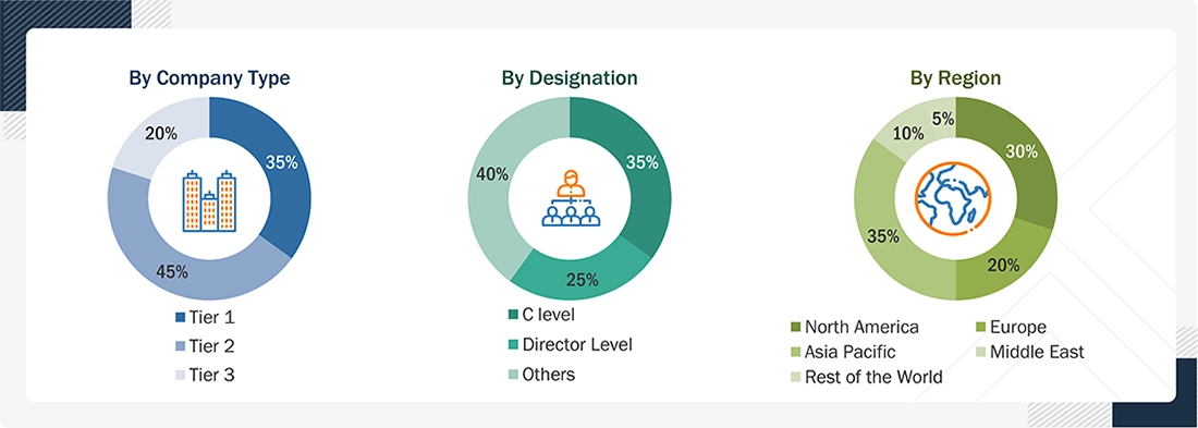
Extensive primary research was conducted after acquiring information on the LEO satellites market through secondary research. Several primary interviews were conducted with market experts from the demand and supply sides across major countries of North America, Europe, the Asia Pacific, the Middle East, and the Rest of the World. Primary data was collected through questionnaires, emails, and telephonic interviews.
Following is the breakdown of primary respondents:
To know about the assumptions considered for the study, download the pdf brochure
Market Size Estimation
Top-down and bottom-up approaches were used to estimate and validate the size of the LEO satellites market. The research methodology used to estimate the size of the market included the following details:
- Key players in the LEO satellites market were identified through secondary research, and their market shares were determined through a combination of primary and secondary research. This included a study of the annual and financial reports of the top market players, as well as extensive interviews with leaders, including directors, engineers, marketing executives, and other key stakeholders of leading companies operating in the market.
- All percentage shares, splits, and breakdowns were determined using secondary sources and verified through primary sources.
- All possible parameters that affect the markets covered in this research study were accounted for, viewed in extensive detail, verified through primary research, and analyzed to obtain the final quantitative and qualitative data on the LEO satellites market. This data was consolidated, enhanced with detailed input, analyzed by MarketsandMarkets, and presented in this report.
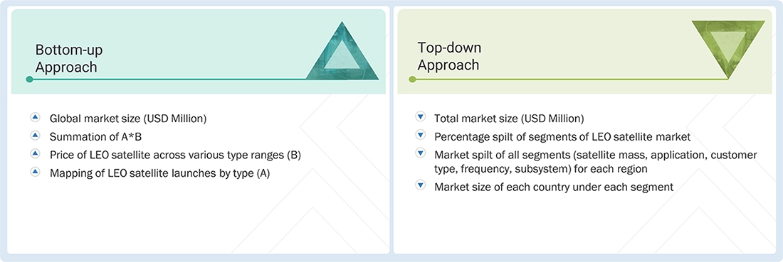
Data Triangulation
After determining the overall market size, the total market was classified into several segments and subsegments. The data triangulation and market breakdown procedures explained below were implemented, wherever applicable, to complete the overall market engineering process and arrive at the estimated market numbers for the market segments and subsegments. The data were triangulated by examining various factors and trends on both the demand and supply sides. Additionally, the market size was validated using top-down and bottom-up approaches.
Market Definition
Low Earth orbit (LEO) satellites are used for commercial, communication, and space research purposes. According to NASA, a low Earth orbit is an Earth-centered orbit with an altitude of 2,000 km (1,200 miles) or less. For the purposes of the commercial use policy, a low Earth orbit is considered the area in Earth orbit near enough to Earth for convenient transportation, communication, observation, and resupply. Unlike satellites in GEO, which must orbit along the Earth’s equator, LEO satellites do not have to follow a fixed path around Earth; their orbital plane can be tilted. This means there are more available routes for satellites in LEO, which is one of the reasons why LEO is a very commonly used orbit.
LEO satellites are used for Earth observation & remote sensing, communication, mapping & navigation, surveillance & security, meteorology, scientific research & exploration, space observation, and various other applications by the defense, civil, commercial, and government verticals.
Key Stakeholders
- Satellite Component Manufacturers
- Satellite Manufacturers
- Satellite Integrators
- Launch Service Providers
- Government and Civil Organizations
- Small Satellite Companies
- Payload Suppliers
- Scientific Institutions
- Meteorological Organizations
Report Objectives
- To define, describe, segment, and forecast the size of the LEO satellites market based on satellite mass, application, customer type, frequency, subsystem, and region
- To forecast the sizes of various segments of the market with respect to these major regions: North America, Europe, Asia Pacific, the Middle East, and the Rest of the World, along with major countries in each of these regions
- To identify and analyze the drivers, restraints, opportunities, and challenges influencing the growth of the market
- To identify industry trends, market trends, and technology trends currently prevailing in the market
- To analyze micromarkets with respect to growth trends, prospects, and their contribution to the overall market
- To analyze opportunities in the market for stakeholders by identifying key market trends
- To profile key market players and comprehensively analyze their market share and core competencies
- To evaluate the degree of competition in the market by analyzing recent developments, such as contracts, agreements, and acquisitions adopted by leading market players
- To identify detailed financial positions, key products, and unique selling points of leading companies in the market
- To provide a detailed competitive landscape of the market, along with market share analysis and revenue analysis of key players
Customization Options
MarketsandMarkets offers the following customizations for this market report:
- Additional country-level analysis of the LEO satellites market
- Profiling of other market players (up to five)
Product Analysis
- Product matrix, which provides a detailed comparison of the product portfolios of each company in the LEO satellites market
Get the Full LEO Satellite Market Report
Full forecast, segment splits, and company analysis for all LEO Satellite Market.
- US LEO Satellite Market
- Canada LEO Satellite Market
- UK LEO Satellite Market
- Germany LEO Satellite Market
- France LEO Satellite Market
- Italy LEO Satellite Market
- Russia LEO Satellite Market
- China LEO Satellite Market
- India LEO Satellite Market
- Japan LEO Satellite Market
- South Korea LEO Satellite Market
- Australia LEO Satellite Market
- Mexico LEO Satellite Market
- Argentina LEO Satellite Market
- Israel LEO Satellite Market
- Rest Of Europe LEO Satellite Market
- Rest Of Asia Pacific LEO Satellite Market
- Rest Of Latin America LEO Satellite Market
- GCC LEO Satellite Market
Need a Tailored Report?
Customize this report to your needs
Get 10% FREE Customization
Customize This Report