
South Korea Geospatial Imagery Analytics Market (2025-2030)

The South Korea Geospatial Imagery Analytics Market was valued at $210.1 Million in 2025 and projected to reach to $344.3 Million by 2030, representing a compound annual growth rate of 10.4%. South Korea's geospatial imagery analytics market is poised for accelerated growth through 2030, driven by increasing government investments in smart infrastructure and the nation's commitment to digital transformation.


| Market Size in | USD 26.32 MN |
| Market Forecast in | |
| CAGR | |
| Forecast Period | |
| Units Considered | Value (USD MN) |
South Korea Geospatial Imagery Analytics Market Trends and Insights
- This growth trajectory reflects South Korea's advanced technological infrastructure and increasing adoption of satellite and drone-based imagery solutions across urban planning, agriculture, and defense sectors.
- South Korea's competitive positioning in the Asia Pacific region is strengthened by its investment in AI-driven analytics platforms and real-time geospatial intelligence capabilities. The market in South Korea is driven by government digitalization initiatives, smart city development projects, and rising demand from both public and private enterprises seeking location-based insights.
- South Korea's strong semiconductor and software industries provide a foundation for developing sophisticated geospatial analytics tools.
- Between 2025 and 2030, South Korea is expected to see accelerated adoption in precision agriculture, environmental monitoring, and autonomous systems, positioning the nation as a regional innovation hub for geospatial technologies..
Key Market Statistics
- CAGR (2025-2030) 10.4% CAGR
- Market Size, 2025 ~USD 210.1 Million
- Forecast, 2030 ~USD 344.3 Million
- Country South Korea
South Korea Geospatial Imagery Analytics Market Overview
Market Valuation & Growth :
South Korea's geospatial imagery analytics market is valued at USD 210.1 million in 2025, with a robust CAGR of 10.4%, significantly outpacing the global average of 8.9%, reaching USD 344.3 million by 2030.
Technological Infrastructure :
South Korea's advanced ICT infrastructure and high digital adoption rates position it as a leader in geospatial technology implementation, with strong government support for satellite and drone-based imagery solutions.
Sector Applications :
Key growth drivers include urban planning modernization, precision agriculture initiatives, smart city development, and defense sector investments leveraging geospatial analytics for enhanced surveillance and monitoring capabilities.
Regional Competitive Advantage :
South Korea's expertise in satellite technology, coupled with domestic companies' innovation in drone analytics and AI-powered image processing, creates a competitive edge in the Asia-Pacific geospatial market.
South Korea Geospatial Imagery Analytics Market Dynamics
- The convergence of 5G connectivity, artificial intelligence, and advanced satellite capabilities enables real-time geospatial analysis across multiple sectors.
- Urban planners are increasingly adopting these solutions for smart city initiatives, while agricultural stakeholders leverage precision farming technologies to optimize crop yields and resource management. The defense and security sectors remain significant growth catalysts, with heightened demand for surveillance and border monitoring applications.
- South Korea's thriving tech ecosystem, combined with favorable regulatory frameworks and substantial R&D investments, positions the country as a regional innovation hub.
- Strategic partnerships between government agencies, private enterprises, and technology providers will further accelerate market penetration and drive the projected 63.8% market expansion over the forecast period..
Market Ecosystem
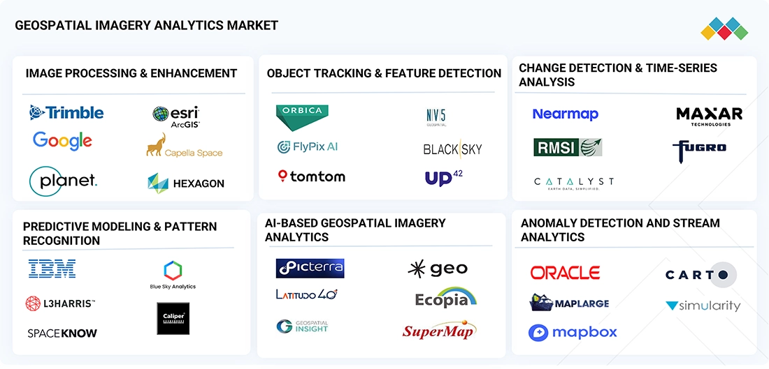
Geospatial Imagery Analytics Market: COMMERCIAL USE CASES ACROSS INDUSTRIES
| COMPANY | USE CASE DESCRIPTION | BENEFITS |
|---|---|---|
 |
Ship detection is vital for maritime surveillance including monitoring traffic, illegal fishing, and sea border activities. AIS cannot detect ships without transponders or those with disconnected transponders. Geocento used SAR imagery to track ships and supplement conventional AIS data with satellite imagery. | Geocento introduced a supplement to conventional AIS data, demonstrating that SAR could track and monitor ships that may not want to be tracked. The solution provided comprehensive monitoring of uncooperative ships using radio waves imaging. |
 |
The insurance sector in India is vital for the nation's financial health. Bajaj Finserv faced challenges with high NPAs, delinquency, and needed spatial capability to look at risk locations. Esri's ArcGIS platform was integrated with the CRM system for identifying areas based on risk propensity. | Bajaj Finserv benefited from Esri's solutions significantly. It reduced delinquency within the customer base, helped filter bad customers at entry level through real-time integration, improved field agent allocation, and enabled proximity-based product offerings using geospatial solutions. |
 |
Madhya Pradesh has 33% forest cover serving as primary resource for multiple industries. The state government needed to track planning changes and land use efficiently. Madhya Pradesh Forestry Department used ERDAS IMAGINE professional and ERDAS APOLLO solutions from Hexagon to conduct time series analysis. | The Madhya Pradesh Forestry Department can effectively detect forest changes over years. The project helps organize a file-based repository, enables geospatial and business data in a human-readable library, and supports vegetation surveillance by identifying forest land encroachment. |
Logos and trademarks shown above are the property of their respective owners. Their use here is for informational and illustrative purposes only.
Related Ecosystem
Analytics
- Natural Language Processing (NLP)
- Machine Learning
- Supply Chain Management
- Predictive Analytics
- Image Sensors
- International Business Machines Corporation
- MICROSOFT CORPORATION
- Oracle Corporation
- SAP SE
Key Takeaways
- South Korea's geospatial imagery analytics market will grow from USD 210.1M (2025) to USD 344.3M (2030) at a 10.4% CAGR, outpacing global growth.
- South Korea's advanced tech ecosystem and government smart city initiatives are primary catalysts for market expansion through 2030.
- South Korea is leveraging AI and machine learning to enhance real-time geospatial intelligence for defense, agriculture, and urban planning applications.
- South Korea's semiconductor and software expertise positions it as a regional leader in developing next-generation geospatial analytics solutions.
Geospatial Imagery Analytics Market Report Scope
| Report Metric | Details |
|---|---|
| Base Year | 2025 |
| Fastest Growing Segment | GEOTEMPORAL DATA (Data Type) |
| Forecast Period | 2025–2030 |
| Growth Rate | CAGR of 8.9% from 2025 to 2030 |
| Largest Segment | GIS & EARTH OBSERVATION (Technology) |
| Market Size Base Year (Billions) | ~USD 12.11 (2025) |
| Revenue Forecast (Billions) | ~USD 18.55 (2030) |
| Segments Covered | Application, Data Modality, Data Source, Offering, Software Functionality, Deployment Mode, Service, Professional Service, Vertical, Technology, Data Type |
South Korea Geospatial Imagery Analytics Market Report Segmentation
11 segment dimensions are covered across the global market.
By Application
- Asset & Infrastructure Management
- Customer Experience Management
- Disaster Management & Emergency Response
- Disease Outbreak Tracking & Resource Allocation
- Emergency Response Management
- Environmental Monitoring & Climate Change
- Insurance Risk Assessment & Claims Validation
- Land Use & Land Cover (Lulc) Classification
- Location Selection & Optimization
- Other Applications
- Precision Farming & Crop Monitoring
- Retail Site Selection & Consumer Footfall Mapping
- Risk Management
- Sales & Marketing Optimization
- Supply Chain & Logistics Monitoring
- Supply Chain Planning& Optimization
- Surveillance & Monitoring
- Target Detection & Strategic Intelligence
- Urban Planning & Smart City Design
By Data Modality
- Image-Based Analytics
- Multimodal Analytics
- Video-Based Analytics
By Data Source
- Aerial Imagery
- Gis & Mapping Platforms
- Satellite Imagery
- Synthetic Aperture Radar (Sar)
- Uav/Drones
By Offering
- Services
- Software
- Solutions
By Software Functionality
- AI-Based Geospatial Imagery Analytics
- AI/ML-Based Geospatial Analytics
- Change Detection & Time-Series Analysis
- Image Processing & Enhancement
- Object Tracking & Feature Detection
- Predictive Modeling & Pattern Recognition
By Deployment Mode
- Cloud
- On-Premises
By Service
- Managed Services
- Professional Services
By Professional Service
- Consulting & Advisory
- Deployment & Integration
- Support & Maintenance
By Vertical
- Agriculture
- Automotive & Transportation
- Automotive, Transportation, And Logistics
- Bfsi
- Construction & Real Estate
- Energy & Utilities
- Government & Defence
- Government & Defense
- Healthcare & Life Sciences
- Insurance
- Insurance & Financial Services
- It/Ites
- Manufacturing
- Media & Entertainment
- Mining
- Mining & Manufacturing
- Other Verticals
- Real Estate & Construction
- Retail & Ecommerce
- Telecommunication
- Telecommunications
- Transportation & Logistics
By Technology
- Gis & Earth Observation
- Global Navigation Satellite System
- ML & Advanced Analytics
- Sensors & Scanning
By Data Type
- 3D Data
- Geotemporal Data
- Other Data Types
- Raster Data
- Tabular Data
- Vector Data
Target Audience
- Government & Urban Planning Agencies : South Korean municipal and national government bodies need market intelligence to inform smart city initiatives, infrastructure development, and digital transformation budgeting aligned with geospatial technology adoption.
- Technology & Software Companies : Domestic and international tech firms require detailed market analysis to identify partnership opportunities, assess competitive positioning, and develop localized geospatial analytics solutions for South Korean enterprises.
- Agricultural & Agribusiness Enterprises : South Korean farming operations and agricultural technology providers need insights into precision agriculture adoption rates, ROI benchmarks, and market trends to optimize resource allocation and technology investments.
- Defense & Security Organizations : South Korean defense contractors and security agencies require market data on surveillance technologies, border monitoring solutions, and geospatial analytics capabilities to support procurement and strategic planning.
- Investment & Venture Capital Firms : Investors targeting South Korea's ICT sector need comprehensive market forecasts, growth drivers, and competitive landscape analysis to identify promising geospatial technology startups and expansion opportunities.
Key Companies in the South Korea Geospatial Imagery Analytics Market
| Company | HQ | Ownership | Strongest segments |
|---|---|---|---|
| BAE SYSTEMS | United Kingdom | Public Company | Image Processing,Object Tracking,Change Detection, |
| IMAGESAT INTERNATIONAL N.V. | Israel | Public Company | Satellite Imagery & Tasking (EROS NG, Global Eye, Direct Access),AI & Data Analytics (ClearSky Analytics, KingFisher, Intelligence-as-a-Service),Satellite Infrastructure & C2 (RUNNER, KNIGHT, ClearSky C2), |
| LEIDOS | United States | ||
| SCIENCE APPLICATIONS INTERNATIONAL CORPORATION (SAIC) | United States | ||
| SKYLAB ANALYTICS | Image Processing,Object Tracking,Change Detection, | ||
| CALIPER CORPORATION | United States | Private Company | Image Processing,Object Tracking,Change Detection, |
| PLANET LABS | United States | Public Company | Image Processing,Change Detection,Object Tracking, |
| L3HARRIS TECHNOLOGIES | United States | Public Company | Image Processing,Object Tracking,Change Detection, |
| FUGRO | Netherlands | Public Company | Image Processing,Object Tracking,Change Detection, |
BAE SYSTEMS
BAE SYSTEMS is a public company founded in 1979 and headquartered in the United Kingdom, with 111,400 employees.
IMAGESAT INTERNATIONAL N.V.
IMAGESAT INTERNATIONAL N.V. is a public company founded in 1997 and based in Israel.
LEIDOS
LEIDOS is a company based in the United States.
SCIENCE APPLICATIONS INTERNATIONAL CORPORATION (SAIC)
SCIENCE APPLICATIONS INTERNATIONAL CORPORATION (SAIC) is a company based in the United States.
SKYLAB ANALYTICS
SKYLAB ANALYTICS is a company.
CALIPER CORPORATION
CALIPER CORPORATION is a private company founded in 1995 and based in the United States, with 469 employees.
PLANET LABS
PLANET LABS is a public company founded in 2010 and based in the United States.
L3HARRIS TECHNOLOGIES
L3HARRIS TECHNOLOGIES is a public company founded in 1895 and based in the United States, with 45,000 employees.
FUGRO
FUGRO is a public company founded in 1962 and headquartered in the Netherlands, with 9,062 employees.
Reasons to Buy this Report
- Market-Specific Insights : Gain detailed understanding of South Korea's unique market dynamics, including sector-specific adoption rates, regulatory environment, and competitive landscape distinct from global market trends.
- Growth Opportunity Identification : Identify high-potential segments within South Korea's market, including urban planning, agriculture, and defense applications, with precise forecasts enabling strategic investment decisions.
- Competitive Intelligence : Understand South Korea's domestic technology providers, their capabilities, market positioning, and partnership opportunities to inform market entry or expansion strategies.
- Regional Expansion Strategy : Leverage South Korea's advanced infrastructure and innovation ecosystem as a springboard for Asia-Pacific expansion, with insights on technology transfer and localization requirements.
- Investment & Funding Decisions : Access comprehensive market data supporting investment thesis development, venture capital allocation, and M&A strategy for geospatial technology companies targeting South Korea.
Frequently asked questions
What is the current market size of geospatial imagery analytics in South Korea?
South Korea's geospatial imagery analytics market was valued at USD 210.1 million in 2025 and is expected to grow to USD 344.3 million by 2030.
What is the projected growth rate for South Korea's geospatial imagery analytics market?
South Korea's market is projected to grow at a compound annual growth rate (CAGR) of 10.4% from 2025 to 2030, exceeding the global average of 8.9%.
Which industries in South Korea are driving geospatial imagery analytics adoption?
South Korea's primary growth drivers include smart city development, precision agriculture, environmental monitoring, defense applications, and autonomous systems development.
How does South Korea's market compare to the global geospatial imagery analytics market?
South Korea's 10.4% CAGR outpaces the global CAGR of 8.9%, reflecting the nation's advanced technological infrastructure and strong government support for digital transformation initiatives.
What technological advantages does South Korea have in geospatial analytics?
South Korea's world-class semiconductor industry, AI expertise, and software development capabilities enable the creation of advanced geospatial analytics platforms with real-time processing and machine learning integration.
RESEARCH METHODOLOGY
This research study for the geospatial imagery analytics market involved extensive secondary sources, directories, journals, and paid databases. Primary sources were mainly industry experts from the core and related industries, preferred geospatial imagery analytics providers, third-party service providers, consulting service providers, end users, and other commercial enterprises. In-depth interviews with primary respondents, including key industry participants and subject matter experts, were conducted to obtain and verify critical qualitative and quantitative information and assess the market’s prospects.
Secondary Research
In the secondary research process, various sources were referred to to identify and collect information for the study. The secondary sources included annual reports, press releases, investor presentations of companies, white papers, journals, certified publications, and articles from recognized authors, directories, and databases. The data was also collected from other secondary sources, such as AI conferences and related magazines. Additionally, the geospatial imagery analytics spending of various countries was extracted from respective sources. Secondary research was used to obtain key information about the industry’s value chain and supply chain to identify key players by solution, service, market classification, and segmentation according to the offerings of major players and industry trends related to solutions, applications, verticals, and regions, and key developments from both market and technology-oriented perspectives.
Primary Research
In the primary research process, various primary sources from both the supply and demand sides were interviewed to obtain qualitative and quantitative information on the market. The primary sources from the supply side included various industry experts, including Chief Experience Officers (CXOs); Vice Presidents (VPs); directors from business development, marketing, and geospatial imagery analytics expertise; related key executives from geospatial imagery analytics solution vendors, SIs, managed service providers, and industry associations; and key opinion leaders.
Primary interviews were conducted to gather insights, such as market statistics, revenue data collected from solutions and services, market breakups, market size estimations, market forecasts, and data triangulation. Primary research also helped understand various trends related to technologies, applications, data types, service types, software types, verticals, and regions. Stakeholders from the demand side, such as Chief Information Officers (CIOs), Chief Technology Officers (CTOs), Chief Strategy Officers (CSOs), and end users using Geospatial imagery analytics solutions, were interviewed to understand the buyer’s perspective on suppliers, products, service providers, and their current usage of Geospatial imagery analytics, which would impact the overall geospatial imagery analytics market.
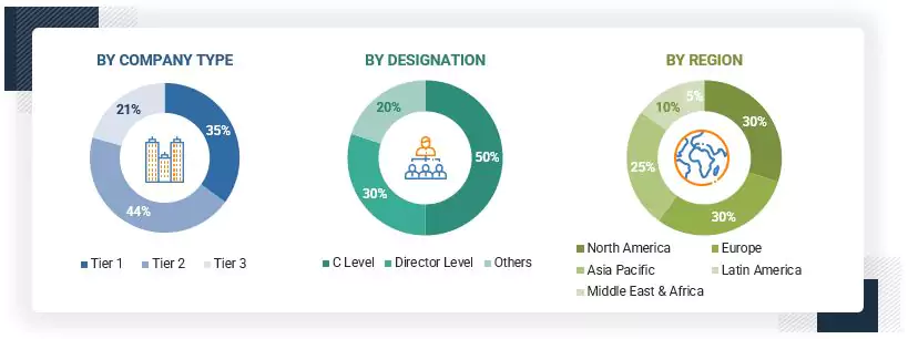
Note: Tier 1 companies account for annual revenue of >USD 10 billion; tier 2 companies’ revenue
ranges between USD 1 and 10 billion; and tier 3 companies’ revenue ranges between USD 500 million–USD 1
billion
Source: MarketsandMarkets Analysis
To know about the assumptions considered for the study, download the pdf brochure
Market Size Estimation
Multiple approaches were adopted to estimate and forecast the geospatial imagery analytics market. The first approach involves estimating the market size by summating companies’ revenue generated by selling solutions and services.
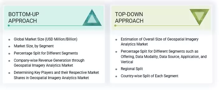
Market Size Estimation Methodology- Top-down approach
In the top-down approach, an exhaustive list of all the vendors offering solutions and services in the geospatial imagery analytics market was prepared. The revenue contribution of the market vendors was estimated through annual reports, press releases, funding, investor presentations, paid databases, and primary interviews. Each vendor's offerings were evaluated based on the breadth of solutions according to software type, service type, technology, data type, and vertical. The aggregate of all the companies’ revenue was extrapolated to reach the overall market size. Each subsegment was studied and analyzed for its global market size and regional penetration. The markets were triangulated through both primary and secondary research. The primary procedure included extensive interviews for key insights from industry leaders, such as CIOs, CEOs, VPs, directors, and marketing executives. The market numbers were further triangulated with the existing MarketsandMarkets repository for validation.
Market Size Estimation Methodology-Bottom-up approach
In the bottom-up approach, the adoption rate of geospatial imagery analytics solutions and services among different end users in key countries with respect to their regions contributing the most to the market share was identified. For cross-validation, the adoption of geospatial imagery analytics solutions among industries, along with different use cases with respect to their regions, was identified and extrapolated. Use cases identified in different regions were given weightage for the market size calculation.
Based on the market numbers, the regional split was determined by primary and secondary sources. The procedure included the analysis of the geospatial imagery analytics market’s regional penetration. Based on secondary research, the regional spending on Information and Communications Technology (ICT), socio-economic analysis of each country, strategic vendor analysis of major geospatial imagery analytics providers, and organic and inorganic business development activities of regional and global players were estimated. With the data triangulation procedure and data validation through primary interviews, the exact values of the overall geospatial imagery analytics market size and segments’ size were determined and confirmed using the study.
Geospatial Imagery Analytics Market : Top-Down and Bottom-Up Approach
Data Triangulation
The market was split into several segments and subsegments after arriving at the overall market size using the market size estimation processes as explained above. To complete the overall market engineering process and arrive at the exact statistics of each market segment and subsegment, data triangulation and market breakup procedures were employed, wherever applicable. The overall market size was then used in the top-down procedure to estimate the size of other individual markets via percentage splits of the market segmentation.
Market Definition
The geospatial imagery analytics comprises digital solutions that enable insurers to manage core processes such as policy administration, underwriting, claims management, and customer engagement. These platforms leverage cloud computing, automation, and data analytics to enhance operational efficiency, improve customer experiences, and support product innovation. They cater to insurers, brokers, and third-party service providers, facilitating seamless integration with ecosystems and regulatory compliance.
Stakeholders
- Geospatial imagery analytics software providers
- Geospatial imagery analytics service providers
- Third-party administrators
- Business analysts
- Cloud service providers
- Consulting service providers
- Enterprise end-users
- Distributors and value-added resellers (VARs)
- Government agencies
- Independent software vendors (ISV)
- Managed service providers
- Support & maintenance service providers
- System integrators (SIs)/migration service providers
- Technology providers
Report Objectives
- To define, describe, and forecast the geospatial imagery analytics market by offering, data modality, data source, application, and vertical
- To provide detailed information related to major factors (drivers, restraints, opportunities, and industry-specific challenges) influencing the market growth
- To analyze the micro markets with respect to individual growth trends, prospects, and their contribution to the total market
- To analyze the opportunities in the market for stakeholders by identifying the high-growth segments of the market
- To analyze opportunities in the market and provide details of the competitive landscape for stakeholders and market leaders
- To forecast the market size of segments for the five main regions: North America, Europe, Asia Pacific, the Middle East & Africa, and Latin America
- To profile the key players and comprehensively analyze their market ranking and core competencies
- To analyze competitive developments, such as partnerships, product launches, and mergers & acquisitions, in the geospatial imagery analytics market
Available Customizations
With the given market data, MarketsandMarkets offers customizations as per your company’s specific needs. The following customization options are available for the report:
Product Analysis
- Product quadrant, which gives a detailed comparison of the product portfolio of each company.
Geographic Analysis as per Feasibility
- Further breakup of the North American geospatial imagery analytics market
- Further breakup of the European market
- Further breakup of the Asia Pacific market
- Further breakup of the Middle Eastern & African market
- Further breakup of the Latin American market
Company Information
- Detailed analysis and profiling of additional market players (up to five)
Get the Full Geospatial Imagery Analytics Market Report
Full forecast, segment splits, and company analysis for all Geospatial Imagery Analytics Market.
- Canada Geospatial Imagery Analytics Market
- US Geospatial Imagery Analytics Market
- UK Geospatial Imagery Analytics Market
- Germany Geospatial Imagery Analytics Market
- France Geospatial Imagery Analytics Market
- Italy Geospatial Imagery Analytics Market
- Spain Geospatial Imagery Analytics Market
- China Geospatial Imagery Analytics Market
- Japan Geospatial Imagery Analytics Market
- India Geospatial Imagery Analytics Market
- UAE Geospatial Imagery Analytics Market
- Qatar Geospatial Imagery Analytics Market
- Israel Geospatial Imagery Analytics Market
- South Africa Geospatial Imagery Analytics Market
- Brazil Geospatial Imagery Analytics Market
- Mexico Geospatial Imagery Analytics Market
- Argentina Geospatial Imagery Analytics Market
- Rest Of Europe Geospatial Imagery Analytics Market
- Anz Geospatial Imagery Analytics Market
- Rest Of Asia Pacific Geospatial Imagery Analytics Market
- Singapore Geospatial Imagery Analytics Market
- Rest Of Latin America Geospatial Imagery Analytics Market
- Saudi Arabia Geospatial Imagery Analytics Market
Need a Tailored Report?
Customize this report to your needs
Get 10% FREE Customization
Customize This Report